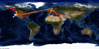
. OnHiatus.com > Journal 1 > Day Index > Journal Entry: June 16, 1998

June 16 - 17, 1998
Davis to San Francisco, California
US's FlagCA's Flag

Map
San Francisco, California:
Latitude: 37° 45' 23" North
Longitude: 122° 27' 52" West
Altitude: 455 feet
From Seattle: 778 miles
Lodging: Friend / Family - Wendy

Map
Today's Travel:
Country: United States
Region: California
Route: SR 113, I-80
Path:Davis - San Francisco, California
Linear:73 miles
Weather: Sunny

Click on map to Zoom in...
Map
Trip Stats to Date:
Days: 432 through 433
Linear Dist: 110897
Countries Visited: 33
Regions Visited: 127
More stats...
Hotels: 87
Friends / Family: 134
Camping: 39
Hostels: 134
Transit: 38
Beers: 1669
Hide...

Journal Entry:
Met up with my friend Amy and went for a (short) swim. Went and had dinner then out with her friend and her roommate.

Next day hung out at Giradelli Square, the Maritime Park, Fort Meyers, and Pier 39 - the normal touristy stuff. Had diner with Wendy then went out with Lance and Rebecca (part of the San Miguel experiences a couple weeks earlier)


Paging: [⇚ Jun 15] | [Jun 18 ⇛] OnHiatus.com > Journal 1 > Day Index > Journal Entry: June 16, 1998